Researching Urban Heat Islands For Key Climate Clues
Those of us involved in green building certifications (LEED, Green Globes, etc.) are intimately familiar with urban heat islands (UHI), both roof and non-roof, since they detract from a project’s overall sustainability.
And all of us, green building practitioners or not, know that our cities have been hotter than usual this year.
So now, more than ever, we need to better understand and improve our climate models. Toward that end, last year, a team of scientists at the U.S. Dept. of Energy's Brookhaven National Laboratory – led by Katia Lamer, director of operations for the Lab’s Center for Multiscale Applied Sensing (CMAS) – built a mobile laboratory to survey climate characteristics in cities. The research objective was to better understand how the effects of UHI might influence weather patterns like rain, and to collect higher resolution data on them, in order to understand possible climate inequities between neighborhoods in the same city.
UHI's are metropolitan areas which are significantly warmer than their surroundings. According to the EPA, many U.S. cities have air temperatures up to 10°F (5.6°C) warmer than the surrounding natural land cover. Structures such as buildings, roads, sidewalks, parking lots, and other infrastructure absorb and re-emit the sun’s heat more than natural landscapes such as forests and water bodies. Urban areas, where these structures are highly concentrated and greenery is limited, thus become “islands” of higher temperatures relative to outlying areas.
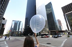
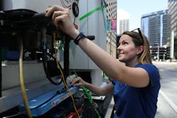
The research team’s mobile lab is completely off-grid and employs a suite of instruments to measure parameters, including air temperature, relative humidity, wind patterns, and air flow (using LIDAR – laser imaging, detection, and ranging – also known as 3-D laser scanning). In addition to such high-tech measurements, the mobile lab is also equipped with helium-filled, "party" balloons outfitted with instruments known as radiosondes to collect and transmit data back to the mobile lab. (Since the mobile lab is intended for use in dense urban areas, it cannot use the traditional larger weather balloons.)
The first deployment of the mobile lab was in NYC, where the scientists measured surface temperatures and wind patterns around Manhattan skyscrapers in order to determine the effect of solar heating on air flow. The air flow is dependent on many factors, including the height and orientation of the building and the temperature differential between the sun side and shade side of the building.
The mobile lab then embarked on a 1,700-mile journey from Upton, NY, to Houston, TX, collecting street-level climate data along the way. According to Lamer, the plan is to build another mobile lab and deploy both to NYC to collect data that could be used to determine the optimum location for a permanent weather station.
Knowing which urban areas and neighborhoods are most vulnerable to climate change will help develop effective mitigation strategies. One such strategy is increasing urban tree canopy. In fact, a study authored by Dr. Brian Stone Jr., Professor in the School of City and Regional Planning at Georgia Tech, suggests that tree canopy may be twice as effective in reducing UHI effects as other strategies.
Look for more about tree canopy in my next Clark’s Remarks.
A regular contributor to HPAC Engineering and a member of its editorial advisory board, the author is a principal at Sustainable Performance Solutions LLC, a south Florida-based engineering firm focusing on energy and sustainability. He can be reached at [email protected].
About the Author
Larry Clark
A member of HPAC Engineering’s Editorial Advisory Board, Lawrence (Larry) Clark, QCxP, GGP, LEED AP+, is principal of Sustainable Performance Solutions LLC, a South Florida-based engineering firm focused on energy and sustainability consulting. He has more than two dozen published articles on HVAC- and energy-related topics to his credit and frequently lectures on green-building best practices, central-energy-plant optimization, and demand-controlled ventilation.